Walt Ranch: Nov12th DEIR public comments audio and article
on the web at: https://sodacanyonroad.org/forum.php?p=448
Bill Hocker | Nov 13, 2014The audio (but not video) of the Nov 12th 2014 meeting convened by Planning Director David Morrison to take public comments regarding the Walt Ranch Erosion Control Plan and Draft EIR is already! up on the county website.
The audio is here
Barry Eberling's NVR article on the meeting is here:
Walt Ranch opponents use signs to make a point
My own take from attending the meeting: Thank goodness that such a large, articulate, organized and passionate group is in the maw of this development monster (see Carolyn Chute's plan left). And thank goodness for a planning director that seems committed to the airing of the impacts of development projects going on in the county.
Much comment was rightly given to the issues of water depletion and woodland conservation. Both are significant issues for the county as a whole, and both have been completely neglected in the development of ever more watershed vineyards. The drought is now forcing the county to look at the water issue, and that issue deserves serious scrutiny on this project. Also let's hope that the the Walt development and the Circle S development adjacent to it, which together amount to 3900 acres of unspoiled county woodland, will begin a discussion of the benefits of adding marginal amounts of vineyard to the Napa grape resource versus a legacy of undeveloped natural habitat to be enjoyed by future generations.
IMHO the Walt Ranch project is not a vineyard conversion. On its face it is a proposal to develop 365 acres (now 288 perhaps) of woodland into vineyards. The tortured vineyard plan (see above) shows just how difficult the development of these acres will be. Major woodland clearing, blasting, major rock removal and road reconstruction. This is a rugged piece of property, and the development costs will far exceed a typical vineyard development. The process has taken 7 years so far, 500 investors are involved; this is not about the yearly return on a 365/288 acre grape harvest. (The fact that the Halls are willing to reduce the number of acres to appease neighbors shows how unimportant the vineyard revenues are). This "erosion control plan'" is really about the development of the infrastructure to serve the 35 properties of a high-end residential-commercial subdivision.
Until now, the county planning department has had a no-questions-asked policy on vineyard conversions as long as an erosion control plan follows county guidelines. All vineyards are seen as having no negative impacts on future county development. That has led to a vast expansion of watershed vineyard property in the county over the last 20 years, in most cases to the county's agricultural benefit. But it is also the path of least resistance to build the roads and water systems necessary for subdivision development: The property is subdivided. Vineyard development insures that infrastructure for the subdivision has no planning hurdles. The subdivision plots are sold. No further planning department involvement is necessary in building 35 residential complexes with their 35 guest houses. Only when the new owners wish to to build tourist-wineries does the planning department again become involved, long after vast areas of the county have been converted from rural to suburban use.
I may be wrong, of course. The ultimate intention of the Halls may be a vineyard and not a housing project. If so, as a gesture of commitment to agriculture, perhaps they might consider removing further development rights from the property deeds as a condition of approval. Barring that, the EIR for this 2300 acre property should also discuss the impacts of the potential development of those 35 parcels to the future of the county. In the words of CEQA, further physical change in the environment "is a reasonably foreseeable impact which may be caused by the project". 15064(d)(3)
Two presentations stood our for me at the hearing:
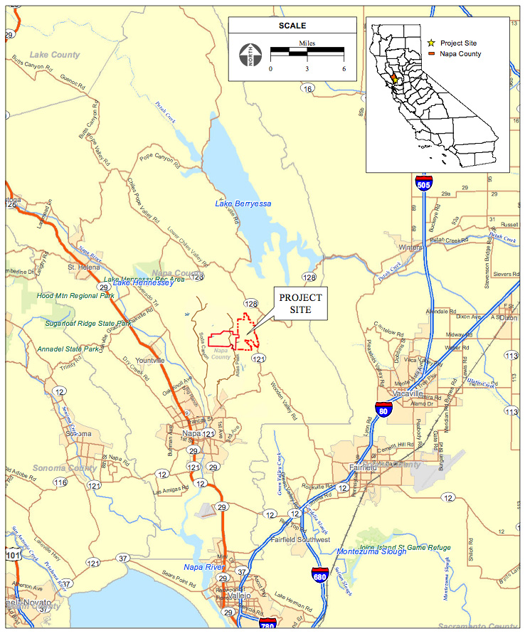
The first was made by Greg Gale, a resident of Atlas Peak Road just south of the Walt Ranch. One of his graphics shows the boundaries of Circle S and Walt properties together on the same map. It is an area about the size of St. Helena. It is about 4 miles wide. This is not an insignificant chunk of the county, and it is being developed into homesites with little input from the planning department and no consideration about the impact of such suburbanization on the agricultural future of the county.
The second was made by Jim Lincoln of the Napa County Farm Bureau. It was a big disappointment from the "stakeholder" we are depending on to save Napa's ag preserve from suburban sprawl. They argued that this unprecedented hearing is an unnecessary intrusion of public scrutiny into the administrative review of erosion control plans, a process that the Farm Bureau had no doubt worked hard to implement. To me it was clearly an apt example of not being able to see the forest for the trees. They seemed institutionally unwilling to make a distinction between trojan vineyards used to garnish housing estates and real ones designed to expand our agricultural resource. It may be a tough call in many circumstances (i.e. Circle S) but with Walt it is not. And they should have used the opportunity explore the distinction between the two.
I am in great hopes that Director Morrison, as evidenced in this hearing and in opening the upcoming review of the WDO, has seen the trajectory of development of the last 15 years, knows that it is leading away from the preservation of an agricultural economy, and is beginning to push on the behemoth of planning policy to shift course - before it is too late.
copyright © sodacanyonroad.org

