
The view from Atlas Peak
on the web at: https://sodacanyonroad.org/forum.php?p=434
Bill Hocker | Nov 9, 2014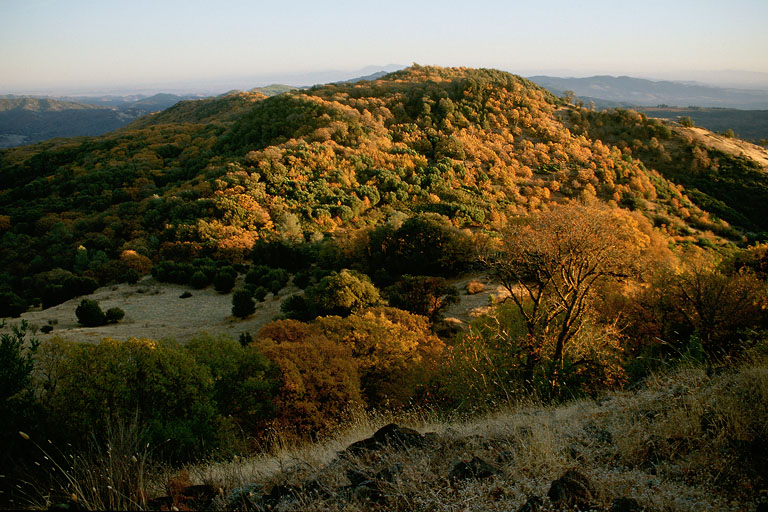
Kelli Cahill, Project Planner
Napa County Planning, Building, & Environmental Services Department
1195 Third Street, Suite 210, Napa, CA 94559
Ms. Cahill,
Above is a view southeast from Atlas Peak along the main ridge of the Howell Mountain Range. To the left is the Lake Berryessa watershed flowing toward the delta. To the right is the Napa River watershed flowing to the bay. The Walt Ranch project, now under your consideration, is further down the ridge, behind the hillside in this photo (perhaps just appearing on the left flank of this hill). The dense oak forest covering its slopes is similar to that seen here. As you no doubt know, it is a heartbreakingly beautiful expanse of native California landscape. The views from this ridge, as can be seen from the photo, are breathtaking .
As you also know, perhaps 15% of the Walt Ranch property will be cleared of its woodlands, blasted in places, to create areas for the vineyard blocks. It is a tortued vinevard plan, a recognition of the ruggedness of the terrain. Many of the blocks are less than two acres in size. Access to the property is along a hair-raising stretch of Hwy 121, 20 minutes from the Napa Valley, and through the residential community of Circle Oaks. The inappropriateness of the terrain for vineyard development and the difficulty of access for equipment and labor make one wonder why such a property was chosen for its intended agricultural use.
The intention may not be simply to increase Napa's agricultural resource. (In this regard, through no fault of the developer, it does a poor job: in the 8 years it has taken to get this far, as many acres of vines have been lost to the nibbling of winery projects and expansions - 4-5 acres on the Mountain Peak project proposed next to me for example - as this development will add. The county bears the impacts of both types of developments with no increase in the resource.)
As unlikely as this rocky ridge is for vines, the proposal represents the "right to farm" of all property owners in the county. In Napa county however, that right also includes the right to an extensive residential compound, guest house and commercial winery that also serves as a tourist event center. Although those uses are not mentioned in the DEIR, given the great effort and expense necessary to develop this convoluted vineyard, one might reasonably ask if the intended use of the 35 parcels on the property might entail further development beyond the proposal before you.
If there is such an intention, it should be made clear by the developer now. If further development is probable, then what we are seeing here is just the first phase of a very high-end residential-commercial subdivision, not merely a vineyard conversion. The planning department, in its mandate to guide the future development of the county, should be considering those impacts now and the EIR should be amended to reflect them. If, however, the intention is that no further development is to take place in the future, then the county should insure that the conditions of approval incorporate that prohibition and be codified into the deeds of the properties.
Hopefully, Napa's long term future will be a part of the WDO discussions coming up next year. Vineyard conversions are just the first step in a long process of suburbanization of Napa land. The effects of that suburbanization in traffic jams, housing projects, stop lights, and the clamor for a Costco are already upon us. If the county is serious about the maintenance of a sustainable agricultural economy in the next 50 years, then that process of suburban development must be broken. A place to begin a commitment to that future is on the spectacular, oak-covered ridge south of Atlas Peak now known as Walt Ranch.
Bill Hocker
3460 Soda Canyon Road
Napa, CA 94558
copyright © sodacanyonroad.org